Black Swift potential survey sites
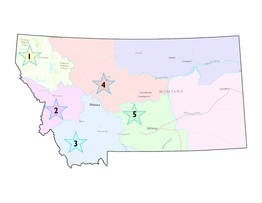
We at Montana Audubon are working throughout western Montana, with Montana Fish, Wildlife & Parks, Glacier National Park, and Glacier National Park Conservancy, to find out just where our Black Swifts are active and breeding. In 2018 work will take place in five of Montana's Fish, Wildlife & Parks Regions:1, 2, 3, 4, and 5. View each region below for a list of falls we are interested in surveying. Explore each region and think about what falls and mountain ranges you may want to visit! Surveys are labeled as EASY, MODERATE, or DIFFICULT and some are overnight trips. Please remember, when visiting Tribal lands, you will need a recreation permit. GPS coordinates are given in NAD 83 lat longs.
Two things you must do prior to surveying
1. Prior to surveys, YOU MUST EMAIL [email protected] with you intended survey location, date and time - please leave this information with someone you trust as well - safety first!
2. In order to be covered during your survey in case of an accident, you MUST fill out either a MT Fish, Wildlife & Parks volunteer form or a Glacier National Park form depending on your survey location.
3. Spend time orienting yourself to the route and any difficult terrain navigation you may encounter. There are many new smart device mapping programs that can assist you in locating your position in the field. Please practice thoughtful and bear-friendly camping practices during surveys.
4. Please remain aware of wildlife you encounter on the trail, and carry your bear spray. Please document any wildlife sightings you would like to share!
5. Don't forget to consider wearing a rock climbing helmet and taking reflective tape to mark your way.
PLEASE NOTE - A double ** preceding the site name indicates there is interest in surveying that site.
> Purcell Mountains - Little North Fork Falls: 48.75651;-115.37532 (west of Lake Koocanusa from the Little North Fork Falls Parking area and Trailhead) EASY - .3 miles round trip
>Access online HERE
> Purcell Mountains - Upper West Fork Yaak Falls: 48.9314;-115.7171 (from the Upper West Fork Yaak Falls Parking Area) EASY - .2 miles round trip
>Access online HERE
>Purcell Mountains - Lower West Fork Yaak Falls: 48.9356;-115.6815 (from the Lower West Fork Yaak Falls Parking Area) EASY - .4 miles round trip
>Access online HERE
>Cabinet Mountains - Leigh Creek Falls: 48.2244;-115.6491 (from Leigh Lake trailhead #132) MODERATE (better as overnight) - strenuous 2.5 miles round trip
>Access online HERE
>Cabinet Mountains - Rock Creek Falls: 48.04007;-115.67656 (from Rock Creek trailhead #935) MODERATE (overnight or day trip) - 5.5 miles round trip
>Access online HERE
>Access online HERE
> Purcell Mountains - Upper West Fork Yaak Falls: 48.9314;-115.7171 (from the Upper West Fork Yaak Falls Parking Area) EASY - .2 miles round trip
>Access online HERE
>Purcell Mountains - Lower West Fork Yaak Falls: 48.9356;-115.6815 (from the Lower West Fork Yaak Falls Parking Area) EASY - .4 miles round trip
>Access online HERE
>Cabinet Mountains - Leigh Creek Falls: 48.2244;-115.6491 (from Leigh Lake trailhead #132) MODERATE (better as overnight) - strenuous 2.5 miles round trip
>Access online HERE
>Cabinet Mountains - Rock Creek Falls: 48.04007;-115.67656 (from Rock Creek trailhead #935) MODERATE (overnight or day trip) - 5.5 miles round trip
>Access online HERE
> Swan Mountains - **Morrell Falls: 47.300973;-113.462892 (Access via HWY 83 and Morrell Creek Road; campgrounds available nearby at Big Larch Campground) EASY - 3.1 miles round trip
>Access online HERE
> Swan Mountains - Lodgepole Creek Falls: 47.206275;-113.200979 (Access via Dunham Creek Road; campground available nearby at Monture Creek; Start hiking at the locked Forest Service gate at Road #4397) EASY - .5 miles round trip
>Access online HERE
> Bitterroot Mountains - **Abha Falls and falls above: 46.580362;-114.204004 (Access via Road; access via Charles Waters Memorial campground and trail head) MODERATE (requires overnight potentially) - 3 miles round trip
>Access online HERE
> Bitterroot Mountains - Kootenai Creek Moss Wall: 46.537868;-114.153752 (Access via Kootenai Creek Trailhead; campgrounds available nearby in nearby canyons) EASY - .5 miles round trip
>Access online HERE
> Bitterroot Mountains - Canyon Falls: 46.245251, -114.320960 (Access via Forest Service Rd #735 and Canyon Creek Trailhead outside of Hamilton; Wilderness camping regulations apply) MODERATE (requires overnight) - 8.2 miles round trip
>Access online HERE
> Anaconda Mountains - Star Falls: 47.300973;-113.462892 (Access via Darby and East Fork Road #9700 and East Fork Bitterroot River Trailhead; campgrounds available nearby at Jennings Campground and on public lands) MODERATE (requires overnight)- 11 miles round trip
>Access online HERE
>Access online HERE
> Swan Mountains - Lodgepole Creek Falls: 47.206275;-113.200979 (Access via Dunham Creek Road; campground available nearby at Monture Creek; Start hiking at the locked Forest Service gate at Road #4397) EASY - .5 miles round trip
>Access online HERE
> Bitterroot Mountains - **Abha Falls and falls above: 46.580362;-114.204004 (Access via Road; access via Charles Waters Memorial campground and trail head) MODERATE (requires overnight potentially) - 3 miles round trip
>Access online HERE
> Bitterroot Mountains - Kootenai Creek Moss Wall: 46.537868;-114.153752 (Access via Kootenai Creek Trailhead; campgrounds available nearby in nearby canyons) EASY - .5 miles round trip
>Access online HERE
> Bitterroot Mountains - Canyon Falls: 46.245251, -114.320960 (Access via Forest Service Rd #735 and Canyon Creek Trailhead outside of Hamilton; Wilderness camping regulations apply) MODERATE (requires overnight) - 8.2 miles round trip
>Access online HERE
> Anaconda Mountains - Star Falls: 47.300973;-113.462892 (Access via Darby and East Fork Road #9700 and East Fork Bitterroot River Trailhead; campgrounds available nearby at Jennings Campground and on public lands) MODERATE (requires overnight)- 11 miles round trip
>Access online HERE
> Swan Mountains - Arnica Falls: 47.901608;-113.711421 (Access via Forest Service Road #5206 off of Lost Creek Road and MT HWY 83; campgrounds available nearby at Swan Lake) EASY - 1.0 mile round trip
>Access online HERE
> Little Belt Mountains - Memorial Falls: 46.912751;-110.69541 (Easy road access from Memorial Falls Park; Many Pines campground available south of Neihart) EASY - .6 mile round trip
>Access online HERE
> Little Belt Mountains - Cataract Falls: 47.322447, -112.604027 ; (Road Access from small parking area off of Elk Creek Road and Augusta Stearns Rd; Bean Lake campground available nearby) EASY - .5 mile round trip, however you must cross a creek
>Access online HERE
> Elkhorn Mountains - Crow Creek Falls: 46.330839, -111.776748; (Road Access from Crow creek Road, Radersburg; trail access via Crow Creek Falls # 109 parking area; undeveloped campsites are available 1.5 miles from the trail head) MODERATE (overnight trip) - 7 mile round trip
>Access online HERE
> Rocky Mountains - Mill Falls: 47.868315,-112.757449; (Access via drive to and trail head from Mill Falls Campground near Choteau) EASY - .2 mile round trip
>Access online HERE
> Rocky Mountains - Our Lake Falls: 47.835845, -112.808213; (Access via South Fork Teton Road and South Fork Teton Trailhead and Our Lake Trail #185) MODERATE (can be overnight trip) - 5.5 mile round trip
>Access online HERE
>Access online HERE
> Little Belt Mountains - Memorial Falls: 46.912751;-110.69541 (Easy road access from Memorial Falls Park; Many Pines campground available south of Neihart) EASY - .6 mile round trip
>Access online HERE
> Little Belt Mountains - Cataract Falls: 47.322447, -112.604027 ; (Road Access from small parking area off of Elk Creek Road and Augusta Stearns Rd; Bean Lake campground available nearby) EASY - .5 mile round trip, however you must cross a creek
>Access online HERE
> Elkhorn Mountains - Crow Creek Falls: 46.330839, -111.776748; (Road Access from Crow creek Road, Radersburg; trail access via Crow Creek Falls # 109 parking area; undeveloped campsites are available 1.5 miles from the trail head) MODERATE (overnight trip) - 7 mile round trip
>Access online HERE
> Rocky Mountains - Mill Falls: 47.868315,-112.757449; (Access via drive to and trail head from Mill Falls Campground near Choteau) EASY - .2 mile round trip
>Access online HERE
> Rocky Mountains - Our Lake Falls: 47.835845, -112.808213; (Access via South Fork Teton Road and South Fork Teton Trailhead and Our Lake Trail #185) MODERATE (can be overnight trip) - 5.5 mile round trip
>Access online HERE
> Gallatin Mountains - Ousel Falls: 45.238847;-111.341543 (Easy road access in the Gallatin Canyon and trail access via Ousel Falls Park parking lot; campgrounds available nearby) EASY/MODERATE - 3.2 miles round trip
>Access online HERE
> Hyalite Canyon - Champange Falls: 45.44768, -110.96241; 7,864' (Easy road access in Hyalite Canyon and trail access via TR427; campgrounds available nearby trail head - overnight required) DIFFICULT (long) - 12.6 miles round trip
>Access online HERE
> Beartooth Mountains - Woodbine Falls: 45.353437; -109.885457 (Easy road access via Woodbine Road and Stillwater River Trail head) EASY - 1.5 miles round trip.
>Access online HERE
> Beartooth Mountains - **Bridal Falls: location of trail head:45.00842, -109.97350(Easy road access via Silvergate MT; campgrounds available nearby trail head - please visit website below for unique access info) EASY - .2 miles round trip >Access online HERE
> Beartooth Mountains - **Silver Falls: 45.012415, -110.001508 (Easy road access via public parking in town - Silvergate MT and the Silver Falls trail head to the west;Pebble Creek campground nearby in Yellowstone - please visit website below for unique access info) EASY - .2 miles round trip
>Access online HERE
> Beartooth Mountains - ** Sheep Creek Falls: 45.01836, -109.96067 (Easy road access via parking area between Cooke City and Silvergate on HWY 212;campgrounds available nearby trail head) MODERATE (trail-less scramble) - .6 miles round trip
>Access online HERE
> Beartooth Mountains - ** Woody Falls: 45.01301;109.91427 (Easy road access west of Cooke City along HWY 212; Take Republic Road south for .2 miles and cross Soda Butte Creek. Take first left fork in road and park in grassy area .2 miles; campgrounds available nearby) EASY - 2.4 miles round trip >Access online HERE
> Gallatin Mountains - Horsetail Falls: (Road Access via East Fork Hyalite canyon Rd and East Fork Hyalite Creek trail head) EASY - 3.0 miles round trip >Access online HERE
>Access online HERE
> Hyalite Canyon - Champange Falls: 45.44768, -110.96241; 7,864' (Easy road access in Hyalite Canyon and trail access via TR427; campgrounds available nearby trail head - overnight required) DIFFICULT (long) - 12.6 miles round trip
>Access online HERE
> Beartooth Mountains - Woodbine Falls: 45.353437; -109.885457 (Easy road access via Woodbine Road and Stillwater River Trail head) EASY - 1.5 miles round trip.
>Access online HERE
> Beartooth Mountains - **Bridal Falls: location of trail head:45.00842, -109.97350(Easy road access via Silvergate MT; campgrounds available nearby trail head - please visit website below for unique access info) EASY - .2 miles round trip >Access online HERE
> Beartooth Mountains - **Silver Falls: 45.012415, -110.001508 (Easy road access via public parking in town - Silvergate MT and the Silver Falls trail head to the west;Pebble Creek campground nearby in Yellowstone - please visit website below for unique access info) EASY - .2 miles round trip
>Access online HERE
> Beartooth Mountains - ** Sheep Creek Falls: 45.01836, -109.96067 (Easy road access via parking area between Cooke City and Silvergate on HWY 212;campgrounds available nearby trail head) MODERATE (trail-less scramble) - .6 miles round trip
>Access online HERE
> Beartooth Mountains - ** Woody Falls: 45.01301;109.91427 (Easy road access west of Cooke City along HWY 212; Take Republic Road south for .2 miles and cross Soda Butte Creek. Take first left fork in road and park in grassy area .2 miles; campgrounds available nearby) EASY - 2.4 miles round trip >Access online HERE
> Gallatin Mountains - Horsetail Falls: (Road Access via East Fork Hyalite canyon Rd and East Fork Hyalite Creek trail head) EASY - 3.0 miles round trip >Access online HERE